|
 Rock Facies: Origin, Depositional Environment
The
sedimentary rock sequence can vary considerably in thickness,
texture, grain size, and lithology from place to place. These
differences create traps that will hold hydrocarbons which are
called stratigraphic traps. Superimposed regional or local structure
may also play a role in stratigraphic traps.
There
are only four basic kinds of stratigraphic traps: unconformities,
porosity permeability pinchouts, reefs, and drape structures.
However, within the permeability pinchout category, there are
many different types. Knowing which type is crucial to understanding
how to explore for, and develop, these reservoirs.
The
methods used to identify stratigraphic traps from logs involve
curve shape analysis for grain size and environment, analysis
of dipmeter data for definition of bedding, and conventional log
analysis calculations for porosity and lithology. In addition,
the use of formation microscanner images to assess detailed stratigraphy
is becoming more common.
The
end result of the analysis is a description of the rock facies
and a three dimensional view of the sedimentary structure. This
will include the type of structure, thickness, reservoir quality,
and if possible, its shape and probable extent.
As
with any log analysis technique, calibration and control by using
core and sample descriptions is very beneficial. In addition,
well to well correlation and mapping can be used to help confirm
stratigraphic interpretation made from dipmeter and curve shape
analysis.
A description of a rock by its detailed type, origin, and depositional
environment is usually called a facies description. It can be
derived by observation of the rocks, or inferred from analysis
and interpretation of well log data. To determine facies from
well logs requires calibration to known rocks (cores, samples,
or outcrops). Understanding the rock facies is the only way to
reconstruct the paleogeography of a rock sequence, which in turn
provides clues as to a potential reservoir's quality and lateral
extent.
Facies
description based on well logs is often called electrofacies analysis,
because electrical logs are used. However, radioactive and acoustic
data is also incorporated, so this Handbook does not stress the
term electrofacies, as it is slightly misleading.
The
rock type can be derived from:
1. observation of samples
2. observation of cores
3. lithology analysis of an adequate log suite
If
the world was perfect, all three sources of data would be available
and would agree with each other. The data sources do not always
agree, so the analyst must learn to compare, contrast, and possibly
discard some data.
The
origin of a rock can be inferred from its present depositional
environment and a reconstruction of paleogeography. Both of these
can, at least sometimes, be inferred from log data, especially
from dipmeter data, which tells us about depositional energy and
direction of transport, in conjunction with other log curves,
which suggest the grain size of the rock. Log analysts usually
concentrate on depositional environment and bedding patterns,
along with dip direction and angle, and provide this information
to geologists who make subsurface maps representing the analysis.
Geologists
who do the whole job need to have special skills in open hole
log analysis and should not rely entirely on the curve shapes
of the raw logs. For example, the curve shapes on SP and gamma
ray logs may be easy to interpret in a conventional shaly sand
sequence, but could be very misleading in a complex sequence of
anhydritic, dolomitic, shaly sands bounded by carbonates.
Radioactive sandstones and carbonates, silty sands (so-called
gas shales), and evaporite sequences require a clear
understanding of all log responses, not just the correlation
curves.
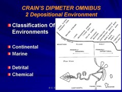
Classification
of Depositional Environments
The
simplest breakdown of depositional environments is:
1. continental
2. coastal or transitional
3. marine
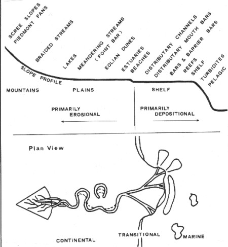
Depositional environments
Most
detrital sediments are continental or transitional, and most chemical
sediments are marine.
Continental
and transitional sediments:
1. glacial - formed by glacial action, eg. gravel
bars, drumlins
2. eolian - formed by wind action, eg. sand dunes
3. alluvial - formed by flooding or when fast moving
water dumps sediment into slow moving water, eg. deltas,
sand bars, beaches
4. fluvial - formed by a river, eg. point bars, channels
5. lacustrine - formed in a lake, eg. mudstones, marls,
chert
6. paludal or carbonaceous - formed in a marsh or
swamp, eg. peat, coal
The
first four describe detrital sediments and the last
two chemical sediments.
Marine
sedimentary rocks:
1. shelf margin - formed at the edge of the continental
shelf
2. inner shelf - formed near shore
3. outer shelf - formed farther from shore
4. atoll/pinnacle reefs - formed by biological skeletons
in shallow water
5. lagoonal/back reef - formed in the quiet shallow
water protected by a reef
6. basinal - formed in deep water
7. evaporitic - formed by evaporation of sea water
All
but the last may be biological sediments and all can
be chemical sediments. However, detrital material
can occur in nearly all of them, including evaporites.
Sedimentary Structures
The term sedimentary structures refers to stratigraphic features
in the subsurface, created by erosion and deposition of sediments,
as opposed to tectonic structures created by tension, compression,
uplift, and subsidence.
There
are four basic kinds of stratigraphic traps: unconformities, porosity
or permeability pinchouts, reefs, and drape structures. River
channels, beaches, bars, and deltas are sedimentary structures,
usually associated with porosity pinchout traps. Drape structures
over these may form additional traps.
Nearly
one-third of the important oil fields of the United States are
stratigraphic traps and many were discovered by random drilling
rather than by scientific exploration methods. This indicates
that strat traps are fairly common in the subsurface and make
up a tremendous potential oil and gas resource. Today, 3-D seismic
and sequence stratigraphy have evolved to the point where start
traps can be defined quite accurately and even very small targets
are drilled on purpose instead of by accident.
The
analysis of sedimentary structures from logs, augmented by core,
sample, and seismic data, is somewhat complex. There are, however,
only a few major types of sedimentation patterns. Most of these
patterns can be represented by a set of models which serve as
a basis for interpretation and comparison by log analysts. The
methods used involve curve shape analysis for grain size and environment,
analysis of dipmeter data for definition of bedding, and conventional
log analysis calculations for porosity and lithology, followed
by geological mapping.
The
difficulties in identifying sedimentary structures, and hence
their associated facies descriptions, include the following:
1. interpretation is based on multiple lines of evidence (eg logs,
cores, inferred geometry, fossils, mineralogy) obtained concurrently
or in no special order.
2.
there may be no unique solution even if all possible data were
available.
3.
interpretation is based on the preponderance of evidence, no single
item will conclusively prove a hypothesis.
4.
absence of a feature is common, so such absences do not help the
analysis.
These
points should be seriously considered when presenting results
of a geological analysis of log data.
Sedimentary
structures can be subdivided into predepositional, syndepositional,
and postdepositional sedimentary features, which aid in describing
the sequence of events which created the structure.
Predepositional
sedimentary structures are those observed on the underside of
a bed. These include erosional features, scour marks, flute marks,
ripple marks, mud cracks, worm burrowings, grooves, and channel
cutting. Of these, only channel cutting may sometimes be recognized
on the dipmeter by the log analyst, although the smaller events
may be seen on Formation Microscanner images.
Postdepositional
sedimentary structures are those observed on the top side of a
bed. These include load casts, quicksand structures, and movement
by slump or creep. Drape due to differential compaction, and its
counterpart, sag, can be measured by the dipmeter and can be diagnostic
of certain types of sedimentary structures.
Syndepositional
sedimentary structures are those occurring within the bed and
take the form of cross bedding or current bedding. We are usually
interested in the magnitude of current bedding angles, their characteristics
such as whether the current beds are planar, wedge shaped, or
festoon type, and their variations versus depth. These factors
provide clues to the depositional mechanism, which in turn define
the significance of the structure as a potential source of hydrocarbons.
Sequence
Stratigraphy and Genetic Units
Sequence stratigraphy is a phrase used to indicate a method for
describing the depositional environment of a sequence of rocks.
The terms stratigraphic unit, genetic unit, or genetic increment
of strata (GIS) are used to describe the presence of a sedimentary
structure. A genetic unit encompasses the structure and its surroundings,
usually the interval between an upper and a lower marker bed or
lower erosional surface, with the sedimentary structure sandwiched
in between. The marker beds are usually shales. The more massive
shale beds are called maximum flooding surfaces and more minor
shales are called local flooding surfaces. The name suggests that
the breaks between successive genetic units are caused by inundation
which stops this particular depositional cycle.
In
this way, the context of the structure in its surroundings is
used to help define the structure, as shown below.
Sequence stratigraphy and genetic units
A
genetic increment of strata (GIS) is made up of a series of depositional sequences, each being
a further series of conformable strata or beds, as shown below. The bedding planes within the depositional sequence are
useful to us, because their dip angle and direction can tell us
something about the arrangement and possible extent of the beds.
The structure of these genetically related beds determines whether
or not a stratigraphic trap is formed.
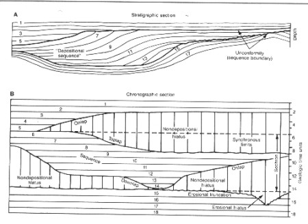
Bedding planes define genetic units
A
genetic sequence of strata (GSS) is a group or series of GIS's,
laid down with reasonable continuity, ie., there are no major
unconformities or major changes in depositional environment. Thus,
a GIS may be repeated several times in vertical succession. A
GSS corresponds roughly to a formation and a GIS to a unit or
member of the formation.
|