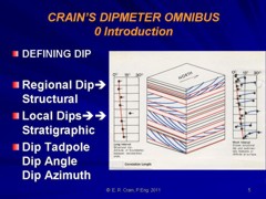
|
 Petroleum
Traps Formed By Structures
Petroleum
Traps Formed By Structures
For a log analyst, the implications of folds and faults are more
important than the creation of mere mountains. Most petroleum
of economic consequence is found in a trap - a set of structural
and stratigraphic conditions in which oil or gas can get in but
can't subsequently get out of the rock. Many types of traps are
created by folding and faulting and are called structural traps.
The traps created by changes in rock type, without folding and
faulting, are called stratigraphic traps. Obviously, combination
structural-stratigraphic traps are possible, and all stratigraphic
traps exist in a regional structural setting, which may influence
the hydrocarbon content.
Rocks
which form a trap do not always contain hydrocarbons, but all
hydrocarbons are contained in some kind of trap. Otherwise they
would flow to the surface of the earth and be dissipated into
the atmosphere or the oceans. Some oil and gas does reach the
surface, and are called seeps. Most early oil discoveries were
located because of a seep at the surface.
The
trapping mechanism is one of the most important aspects of petroleum
geology. For example, if porous rock has been folded upward into
a dome or anticline, oil and gas may collect at the top of such
a structure. It may be kept from escaping by an overlying nonporous
layer of rock. Traps can also be formed by faults, which allow
a porous layer to be thrust against a nonporous layer, thereby
sealing in the hydrocarbon. Examples are shown below.
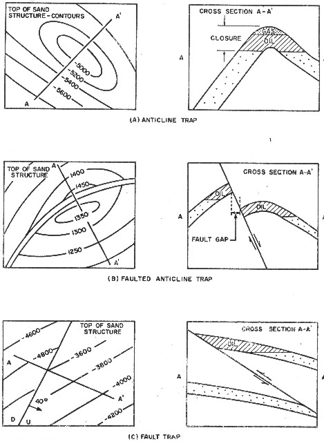
Structural traps
Traps
filled with hydrocarbons can be rearranged structurally by diastrophic
forces, thus un-trapping the hydrocarbons. The presence of oil
staining or fluorescence on rock samples from depleted reservoirs
is relatively common, indicating that trapped oil has been released
by geologic forces on numerous occasions.
Stratigraphic
traps are created by the nature of the depositional sequence itself
and do not depend on deformation of the rocks. For example, a
sandstone that may have once been an old beach usually tapers
off to a wedge ending between two layers of rock that are not
porous. If one edge of the wedge is high relative to the other,
oil and gas could collect in the updip edge and could go no further.
Ancient river valleys, sand bars, beaches, and delta fronts can
be sealed by impervious rock above and below so as to create traps
of many varied shapes and sizes. Some traps have both a structural
and a stratigraphic component, such as reef and salt dome traps.
The
fluids trapped in a reservoir are segregated by gravity. Since
gas is lighter than oil, it will rise to the top of the trap.
Some reservoirs do not contain sufficient gas to create a separate
gas cap. Since gas can be dissolved in oil, most oil wells produce
some dissolved gas. Water is heavier than conventional light oil,
so the free water in the reservoir will be forced to the bottom
of the trap. In heavy oil wells, it is possible to have water
on top of the oil column, or even interbedded within the oil,
depending on the oil gravity and the timing of the oil degradation.
The
vertical relief of anticlines varies, ranging from a few feet
to several thousand feet. Some of the largest oil fields of the
world are anticlinal traps. The Abqaiq pool in Saudi Arabia is
a large anticline, 25 miles long and 6 miles wide, This structure
produced about one billion barrels of oil in 8 years. The Abqaiq
anticline contrasts sharply with the small Wilcox structures of
central Oklahoma that cover only 100 acres.
Asymmetrical
anticlines are also formed by lateral compression. Typically these
structures are elongate and often occur in trends that parallel
the major uplifts of the geologic province. Many of the surface
anticlines in the Rocky Mountains fall in this category. Frequently
the center of the surface anticline forms a topographic low where
erosion has cut through otherwise resistant beds, which have been
fractured by the folding process. The resistant beds form prominent
scarps or rim rock around the basin that are easily recognized.
The axis of the asymmetrical anticline may shift with depth. As
a consequence, the deep seated fold may not lie directly under
the surface anticline.
Many
of the larger anticlines of the world are faulted. The fault patterns
range from simple to exceedingly complex, such as those found
in the Rocky Mountains and California. Production is often confined
to the upthrown block, but this does not entirely eliminate the
downthrown side of the fault as a potential trap. In this type
of structure, the role of faulting appears to be of minor importance
in controlling accumulation on the crest of the fold. Faulted
anticlines occur in nearly all geologic provinces and can usually
be mapped by geophysical surveys. The Gulf of Suez fields in Egypt
is a classic faulted anticline structures.
Overthrust
anticlines are formed by compression and occur along the edges
of major uplifts as narrow folded belts. The geology in these
thrust belts is very complex, but some structures are prolific
and may develop into major fields. Turner Valley in the Alberta
foothills of Canada is a classic example of an overthrust fold
and has produced 100 million barrels since its discovery in 1915.
Normal
or gravity faults control production in many oil fields in most
of the geologic provinces of the world. This type of trap occurs
wherever the region has been folded or uplifted. Often the trap
is formed by a combination of both folding and faulting. Fields
can occur in narrow belts along a fault system for hundreds of
miles. Good examples of gravity faults occur in the Niger Delta.
Fault
planes formed by gravity or tension usually dip at 45-60 degrees.
Invariably, wells that pass through a normal fault drill an abnormally
short section of sediments. The thickness of the missing section
is equal to the throw of the fault. This is a good criterion for
locating the fault if there is enough well control. In the absence
of sufficient data, it is easy to mistake the missing section
caused by faulting for an erosional surface, which also creates
a
missing section.
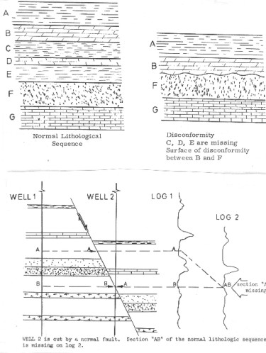
Missing section due to normal fault
Reverse
faulting occurs in areas that have been subjected to compression.
Wells that pass through these fault planes will normally repeat
section, going from older beds above the fault into younger beds
below the fault. Reverse or thrust faulting occurs around the
flanks of mountain uplifts where horizontal compression plays
a dominant role in the forming of local and regional structures.
Faulting
often breaks an oil field into several separate pools or fault
blocks. The faults may parallel each other, or they may intersect
to form several traps. The fault patterns can be related to the
regional and local geology and drilling along these trends is
usually more successful than random drilling. An example is the
Austin Chalk play in the southern USA, where production is greatly
enhanced by fractures associated with minor faulting. An example
of a field with many semi-radial faults is Hibernia, offshore
east coast Canada.
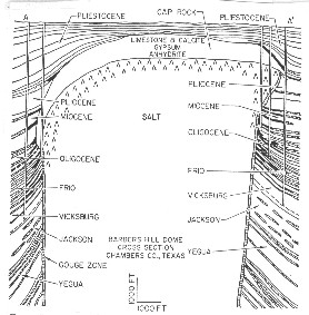 Complex
faults are typical of salt domes. A salt dome field may produce
from 10 or 20 separate reservoirs, or even more because of the
faulting and geometry of the flanking sandstone layers. A simple
example is given at the right. Complex
faults are typical of salt domes. A salt dome field may produce
from 10 or 20 separate reservoirs, or even more because of the
faulting and geometry of the flanking sandstone layers. A simple
example is given at the right.
Salt dome traps

The
caprock is a reservoir in certain Gulf Coast fields. Both gravity
and seismic surveys are extremely useful methods of searching
for salt dome features. Geologists suspect that many of the structural
features in east Texas and north Louisiana are also related to
deep seated salt movement.
Salt
solution plays an important role in other areas of the world,
forming traps across the tops or flanks of un-dissolved salt.
A striking example involves a map of the oilfields of Saskatchewan
- the vast majority form a semicircle around the edge of the major
salt solution basin in the Devonian, nearly 400 miles in diameter.
Impact
craters, shown below, also form structural traps. They
are usually small and difficult to find, but several are known
in Saskatchewan, North Dakota, and other areas of the USA, in
formations of various ages.
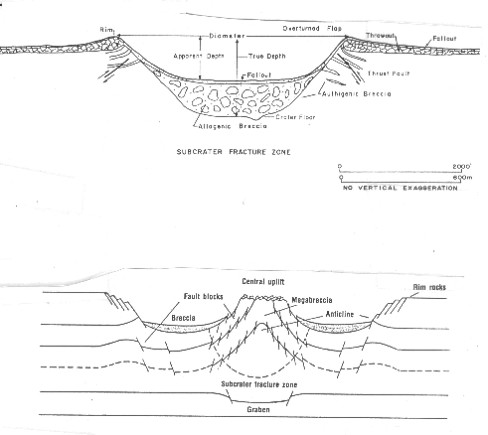
Impact crater traps
Impact
crater traps have hundreds of small faults and complex structure.
Regional dip superimposed on such a trap makes the accumulation
of hydrocarbons exceedingly complicated.
|