|
 Petroleum
Traps Formed By Stratigraphy
Petroleum
Traps Formed By Stratigraphy
An appreciation of sedimentary structures helps greatly in
trying to analyze dipmeter patterns. Some dip patterns can
point to several possibilities, so it is nice to know what
is possible, what is probable, and what is impossible (bed
boundaries that cross each other, for example.
1. Unconformities
An unconformity is a hiatus in the normal geological sequence
caused by a break in the process of deposition, by erosion, or
by structural deformation. It results in a missing amount of sediments
corresponding to a missing geological time as compared to the
normal sequence. It is made of two different series of strata
separated by a surface of unconformity.
Strictly
speaking, there are four main types of unconformities:
1. nonconformity, in which sediments overlie igneous rocks.
2. paraunconformity, in which strata are parallel on both sides
of the unconformity, but some of the rock sequence is missing,
due to lack of deposition (not due to erosion).
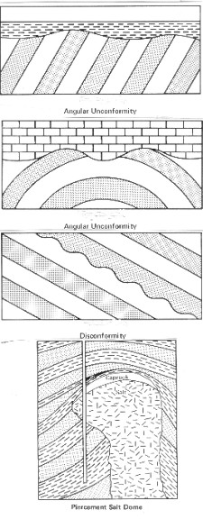
3. disconformity, in which strata are also parallel on both sides,
but there is an erosional surface as well as the missing section.
Lack of deposition may also have occurred.
4. angular unconformity, in which the strata above and below are
not parallel. Erosion has almost always taken place.
The
last two mentioned are the only ones to concern us, and are illustrated
below.
 Unconformities and disconformity Unconformities and disconformity

The
contact between sedimentary layers and intrusive salt, gypsum,
and shale domes is very similar to an angular unconformity, but
the process is caused by compression and the traps are considered
to be structural rather than stratigraphic.
Unconformities
can be classified:
1.
according to lateral extent as:
- regional, occurs across a large area or possibly the entire
basin
- local, occurs over a small area
2.
according to the amount of missing geological time as:
- major, where a long time sequence is missing
- minor, where a short time span is missing
Since
there is no change in dip trend between the upper and lower strata
of a paraunconformity or a disconformity, it may go completely
unnoticed except for changes in microfossils. However, a disconformity
may be detected by the following features:
-
weathered zone, reflecting the effects of the work of ground water,
such as solution vugs or caverns, brecchia, jumbled rock, or cross
bedding occurring immediately above or below the the disconformity
surface.
-
local erosion, which can result in a local high or local low at
the unconformity surface. When deposition resumes, this dipping
surface is filled by the overlying sediments. The erosional surface
is sometimes apparent on logs.
Disconformities
and angular unconformities are relatively easy to spot on a dipmeter
log; they are the so-called black patterns, or major changes in
dip angle or direction. The dip of bedding planes above an angular
unconformity differs from that of the bedding planes below. The
underlying strata have been tilted during the period of non-deposition.
Like faults, angular unconformities are characterized by a change
of trend of dip (either dip angle or dip azimuth or both). In
addition, erosion may cut a pre-existing structure and produce
an irregular topography, characterized by varying dip angles and
directions on the old surface.
There
may be no significant curve shape anomaly at an unconformity,
for example where one shale bed lies unconformably on another.
There may be a resistivity or apparent porosity change due to
differences in silt content or shale compaction. If the unconformity
is at the top of a sandstone, the erosional surface may create
a very sharp break at the top of a regressive sequence or at the
top of a high energy sequence, but may go unnoticed at the top
of a transgressive sequence.
It
is easy to mistake a fault for an angular unconformity and vice
versa, based on dip information only. In general, dip is steeper
below the unconformity surface than above it, although more recent
tilting may have altered this relationship. Weathering, local
erosion, and change in rock quality may occur at an angular unconformity
as well as at a disconformity, and gouge or brecchia may occur
at a fault. Both cases produce erratic dips at the boundary.
Unconformities
and disconformities do not always form traps, but if porous rock
lies below and shale above the unconformity, the regional picture
may provide the trapping mechanism, especially in the case of
angular unconformities. The most familiar unconformity sand trap
in the United States is the East Texas field; it has produced
over 3.1 billion barrels of oil since its discovery.
A
similar unconformity in Canada, with far less reserves, is formed
by the Mississippian unconformity, capped by Jurassic shales.
Similar traps, not too far away, occur where the Jurassic sandstones
pinch out under the Lower Cretaceous shales. A typical unconformity
trap is illustrated below.
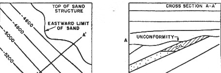
Typical unconformity trap
2.
Porosity Permeability Pinchouts
As a general rule, shallow water sandstone beds are likely to
thin, and deeper water beds such as limestones are likely to thicken,
away from the shoreline. If a rock layer continues to thin in
a certain direction, it may finally pinchout or lense-out altogether.
The beds above and below it will then become contiguous. This
can happen to blanket sands, beaches, bars, and delta fronts and
are called sand pinchouts. River channel fill and point bars in
meandering streams and rivers thin toward their edges; this effect
is also called a pinchout. The thin edge of any sand body can
be described as a pinchout.
The
large Pembina field in Alberta is a good example of this type
of trap. These traps extend for many miles along a fairly narrow
belt at the updip limit of the sand. Although sand pinchouts are
stratigraphic traps, folding and faulting may be important in
controlling production.
Frequently
porous limestone or dolomite grades updip into a non-porous rock.
These are called porosity permeability pinchouts and may be of
local or regional importance. The Carthage gas field in east Texas
is an excellent example of a permeability pinchout. The producing
limestone grades updip into an impermeable limestone that is barren.
Later arching of the sediments formed the Carthage pool that covers
nearly 250,000 acres.
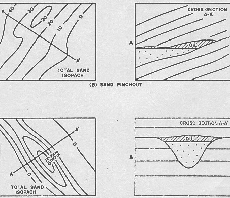
Sand pinchout (top) and Sand channel (bottom)
A
porosity permeability trap is formed when the thin edge of the
porosity is updip from the thicker part of the zone.
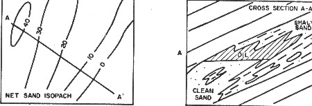
Permeability pinchout trap (shaly sand shown, similar traps
are also formed in carbonates)
Obviously
very complex combinations of deltas, cut by channels, and faced
by offshore marine bars can exist. An example is shown below. The same comment is true in river channel cut and fill
situations where meandering streams can provide a complex depositional
pattern, unfortunately seen only as isolated one dimensional views
by the logs run in the well bore.
Complex stratigraphic traps
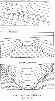
3.
Reef Traps
Reefs are productive in many parts of the world. Many types exist,
such as atolls, table reefs, pinnacle reefs, barrier reefs, fringing
reefs, biostromes, and bioherms. They occur as small dome like
features that may be reflected in the overlying sediments by drape.
Drape is described in the next section of this Chapter. Some reef
trends extend for hundreds of miles, such as the Leduc reef trend
in Alberta. The size of a reef ranges from a few acres to several
square miles. Seismic exploration is the best way to find reefs.
The
reef core grows upward and usually outward as the sea level rises.
Detrital reef material falls on the ocean side, forming the fore
reef. The back reef is formed on the lagoon or quiet side by deposition
of limestone and lime mud.
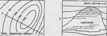
Reef trap
If
sea level rises too fast, the reef may drown and die. If water
level drops it may begin to grow again, forming very complex structures.
Some examples are shown below.
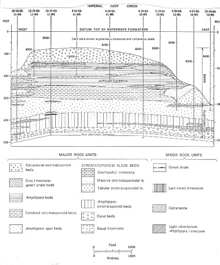
Complex lithology of a Devonian reef
Reefs
are usually easily identified by draping dips, often extending
several hundred to a few thousand feet above the reef. Dips in
the reef core and fore reef are erratic, and those in the back
reef may be visible or nonexistent.
4. Drape Traps
 Differential
compaction causes drape over reefs and sand bodies and this can
form traps. A sandstone or carbonate layer above the bar or reef
can be bent in such a way as to have closure, that is, the ability
to contain and trap hydrocarbons. The bending is caused by the
fact that the reef or sand body does not compress to the same
degree as the shales to either side of it. Therefore a topographic
high can be propagated upward through the section for quite some
distance. Differential
compaction causes drape over reefs and sand bodies and this can
form traps. A sandstone or carbonate layer above the bar or reef
can be bent in such a way as to have closure, that is, the ability
to contain and trap hydrocarbons. The bending is caused by the
fact that the reef or sand body does not compress to the same
degree as the shales to either side of it. Therefore a topographic
high can be propagated upward through the section for quite some
distance.
Drape and sag
These
traps look like folds in a cross section or on the dipmeter patterns.
They were not formed by tectonic activity, but rather by the sedimentary
process itself. Dips underneath the reef or bar will be regional,
in contrast to the anticline. Drape is important in identifying
sedimentary structures from dipmeter data, and is often overlooked
as a trapping mechanism in the beds lying above the target formation.
Drape
is illustrated schematically for both the reef
and the sand bar case. Channel fill can also cause drape, again
due to differential compaction of surrounding shale. Bedding inside
the channel may be complex, but is usually regional under the
channel. However, the mass of a reef or channel sand may compact
the rock under the body, causing apparent sag below the base of
the zone.
|